


File:Thai expressway system overview map.png
From Phuketer
Size of this preview: 500 × 600 pixels. Other resolutions: 200 × 240 pixels | 400 × 480 pixels | 640 × 768 pixels | 1,239 × 1,486 pixels.
Original file (1,239 × 1,486 pixels, file size: 1,011 KB, MIME type: image/png)
Summary
| Description |
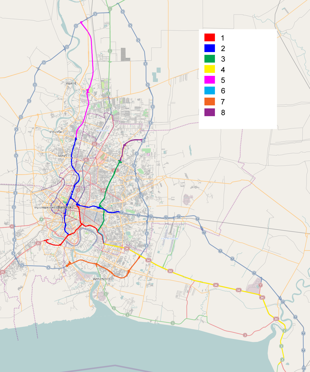
English: Overview map of Thailand's expressway system
1 First Stage Expressway System (officially known as Chalerm Maha Nakhon Expressway) 2 Second Stage Expressway System (Si Rat Expressway) 3 Ramindra – At Narong Expressway (Chalong Rat Expressway) 4 Bang Na Expressway (Burapha Withi Expressway) 5 Bang Pa-in – Pak Kret Expressway (Udon Ratthaya Expressway) 6 Third Stage Expressway System, S1 section 7 Bang Phli – Suk Sawat Expressway 8 Ramindra – Outer Ring Road Expressway |
|||
| Date | – 2011-08-05 | |||
| Source | OpenStreetMap image, with modifications by uploader | |||
| Author | OpenStreetMap contributors, Paul_012 | |||
| Other versions |
|


| Description |
This map was created from OpenStreetMap project data, collected by the community. This map may be incomplete, and may contain errors. Don't rely solely on it for navigation. |
| Date | (see file history) |
| Source | openstreetmap.org |
| Creator |
OpenStreetMap contributors |
| Permission (Reusing this file) |
OpenStreetMap data and maps are licensed under the Creative Commons Attribution-ShareAlike 2.0 license (CC-BY-SA 2.0). This file is licensed under the Creative Commons Attribution-Share Alike 2.0 Generic license.
|
| Georeferencing | If inappropriate please set warp_status = skip to hide. |
Licensing
This file is licensed under the Creative Commons Attribution-Share Alike 2.0 Generic license.
- You are free:
- to share – to copy, distribute and transmit the work
- to remix – to adapt the work
- Under the following conditions:
- attribution – You must give appropriate credit, provide a link to the license, and indicate if changes were made. You may do so in any reasonable manner, but not in any way that suggests the licensor endorses you or your use.
- share alike – If you remix, transform, or build upon the material, you must distribute your contributions under the same or compatible license as the original.
File history
Click on a date/time to view the file as it appeared at that time.
| Date/Time | Thumbnail | Dimensions | User | Comment | |
|---|---|---|---|---|---|
| current | 03:57, 6 August 2011 | | 1,239 × 1,486 (1,011 KB) | wikimediacommons>Paul 012 | {{Information |Description ={{en|1=Overview map of Thailand's expressway system 1 First Stage Expressway System (officially known as Chalerm Maha Nakhon Expressway) 2 Second Stage Expressway System (Si Rat Expressway) 3 Ramindra – At Narong Expresswa |
File usage
The following page uses this file:
