


File:Gulf of Thailand.svg
From Phuketer

Size of this PNG preview of this SVG file: 488 × 479 pixels. Other resolutions: 245 × 240 pixels | 489 × 480 pixels | 782 × 768 pixels | 1,043 × 1,024 pixels | 2,086 × 2,048 pixels.
Original file (SVG file, nominally 488 × 479 pixels, file size: 387 KB)
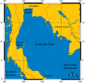
Mercator projection of Gulf of Thailand.
Public Domain map created by Online Map Creation:
http://www.aquarius.geomar.de/omc/omc_intro.html archive copy at the Wayback Machine
Modified by me (User:Feydey).
Other versions
-
 Italiano
 -
 Македонски
 -
 বাংলা
বাংলা


| This work has been released into the public domain by its author, User:Feydey. This applies worldwide. In some countries this may not be legally possible; if so: User:Feydey grants anyone the right to use this work for any purpose, without any conditions, unless such conditions are required by law.
|
derivative works
Derivative works of this file:
File history
Click on a date/time to view the file as it appeared at that time.
| Date/Time | Thumbnail | Dimensions | User | Comment | |
|---|---|---|---|---|---|
| current | 18:06, 16 January 2020 | | 488 × 479 (387 KB) | wikimediacommons>Paul 012 | The label "Andaman Sea" was in the area officially defined as the Strait of Malacca. |
File usage
The following page uses this file:
