File:1062-mu-koh-lanta-national-park-05.jpg
This file is from Wikimedia Commons and may be used by other projects. The description on its file description page there is shown below.
Summary
| Description1062-mu-koh-lanta-national-park-05.jpg |
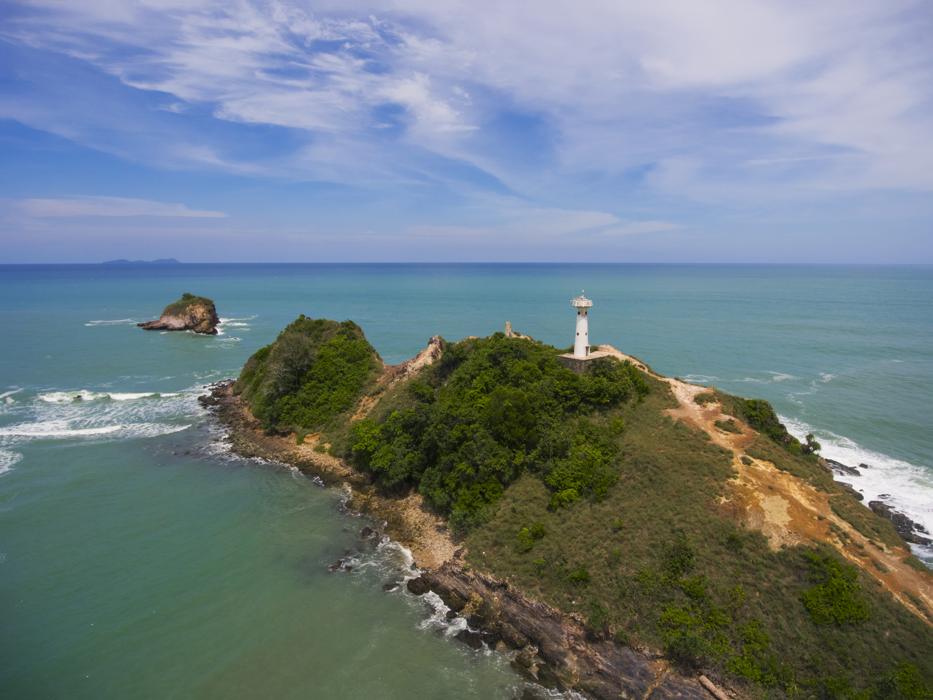
ไทย: อุทยานแห่งชาติหมู่เกาะลันตา จังหวัดกระบี่
|
||
| Date | Taken on 26 June 2016, 11:43:24 | ||
| Source | Own work | ||
| Author | Wanjak Atikomchakorn |
| Camera location | 7° 28′ 08.48″ N, 99° 05′ 55.57″ E | View this and other nearby images on: OpenStreetMap |
|---|
Licensing
- You are free:
- to share – to copy, distribute and transmit the work
- to remix – to adapt the work
- Under the following conditions:
- attribution – You must give appropriate credit, provide a link to the license, and indicate if changes were made. You may do so in any reasonable manner, but not in any way that suggests the licensor endorses you or your use.
- share alike – If you remix, transform, or build upon the material, you must distribute your contributions under the same or compatible license as the original.
This image was uploaded as part of Wiki Loves Earth 2016.
aragonés | العربية | asturianu | azərbaycanca | беларуская (тарашкевіца) | български | বাংলা | brezhoneg | català | čeština | Cymraeg | Deutsch | Ελληνικά | English | español | eesti | euskara | فارسی | français | galego | עברית | hrvatski | հայերեն | Bahasa Indonesia | italiano | 日本語 | ქართული | 한국어 | latviešu | македонски | മലയാളം | मराठी | Bahasa Melayu | norsk bokmål | नेपाली | Nederlands | norsk | polski | português | português do Brasil | русский | sicilianu | shqip | slovenščina | српски / srpski | svenska | ไทย | Türkçe | українська | اردو | 中文 | 中文(台灣) | +/− |
This image has been assessed using the Quality image guidelines and is considered a Quality image.
العربية ∙ جازايرية ∙ беларуская ∙ беларуская (тарашкевіца) ∙ български ∙ বাংলা ∙ català ∙ čeština ∙ Cymraeg ∙ Deutsch ∙ Schweizer Hochdeutsch ∙ Zazaki ∙ Ελληνικά ∙ English ∙ Esperanto ∙ español ∙ eesti ∙ euskara ∙ فارسی ∙ suomi ∙ français ∙ galego ∙ עברית ∙ हिन्दी ∙ hrvatski ∙ magyar ∙ հայերեն ∙ Bahasa Indonesia ∙ italiano ∙ 日本語 ∙ Jawa ∙ ქართული ∙ Qaraqalpaqsha ∙ 한국어 ∙ kurdî ∙ кыргызча ∙ Latina ∙ Lëtzebuergesch ∙ lietuvių ∙ македонски ∙ മലയാളം ∙ मराठी ∙ Bahasa Melayu ∙ Nederlands ∙ ਪੰਜਾਬੀ ∙ Norfuk / Pitkern ∙ polski ∙ português ∙ português do Brasil ∙ rumantsch ∙ română ∙ русский ∙ sicilianu ∙ slovenčina ∙ slovenščina ∙ shqip ∙ српски / srpski ∙ svenska ∙ தமிழ் ∙ తెలుగు ∙ ไทย ∙ Tagalog ∙ toki pona ∙ Türkçe ∙ українська ∙ oʻzbekcha / ўзбекча ∙ vèneto ∙ Tiếng Việt ∙ 中文 ∙ 中文(简体) ∙ 中文(繁體) ∙ +/− |
Captions
Items portrayed in this file
depicts
some value
26 June 2016
7°28'8.48129"N, 99°5'55.56880"E
image/jpeg
226c2649b5d748b32faf94b27327cc5cc33ad992
6,128,649 byte
2,969 pixel
3,953 pixel
0.000357142857142857 second
2.8
100
File history
Click on a date/time to view the file as it appeared at that time.
| Date/Time | Thumbnail | Dimensions | User | Comment | |
|---|---|---|---|---|---|
| current | 19:11, 29 June 2016 | 3,953 × 2,969 (5.84 MB) | wikimediacommons>Bkkgraff | Mu Ko Lanta National Park |
File usage
The following page uses this file:
Metadata
This file contains additional information, probably added from the digital camera or scanner used to create or digitize it.
If the file has been modified from its original state, some details may not fully reflect the modified file.
| Camera manufacturer | DJI |
|---|---|
| Camera model | FC330 |
| Exposure time | 1/2,800 sec (0.00035714285714286) |
| F Number | f/2.8 |
| ISO speed rating | 100 |
| Date and time of data generation | 11:43, 26 June 2016 |
| Latitude | 7° 28′ 8.48″ N |
| Longitude | 99° 5′ 55.57″ E |
| Altitude | 36.9 meters above sea level |
| Orientation | Normal |
| Horizontal resolution | 300 dpi |
| Vertical resolution | 300 dpi |
| Software used | Adobe Photoshop CC 2014 (Macintosh) |
| File change date and time | 19:01, 29 June 2016 |
| Exposure Program | 58655 |
| Exif version | 2.3 |
| Date and time of digitizing | 11:43, 26 June 2016 |
| APEX shutter speed | 11.451211 |
| APEX aperture | 2.970854 |
| APEX exposure bias | −0.65625 |
| Maximum land aperture | 2 APEX (f/2) |
| Subject distance | 0 meters |
| Metering mode | Center weighted average |
| Light source | Unknown |
| Flash | Flash did not fire, No flash function |
| Color space | Uncalibrated |
| File source | Digital still camera |
| Scene type | A directly photographed image |
| Custom image processing | Normal process |
| Exposure mode | Auto exposure |
| White balance | Auto white balance |
| Digital zoom ratio | 0 |
| Scene capture type | Standard |
| Scene control | None |
| Contrast | Normal |
| Saturation | Normal |
| Sharpness | Normal |
| Subject distance range | Unknown |
| GPS tag version | 0.0.3.2 |
| Serial number of camera | 2014031100 |
| Rating (out of 5) | 0 |
| Date metadata was last modified | 02:01, 30 June 2016 |
| Unique ID of original document | B3C1922A450F2F91102B4EAF5B279D60 |
| IIM version | 32,767 |
